Jerash Jordan: Explore the Greco-Roman City Ruins
The Pompeii of the East — Best Preserved Roman City
Jerash Jordan: a complete guide to ancient Gerasa
Jerash is one of the most impressive ancient cities in Jordan and among the best-preserved Roman provincial urban sites in the world. About 50 kilometers north of Amman, the ruins occupy a green valley beside the modern city. Visitors can follow gateways, paved streets, plazas, temples, theaters, fountains and churches in a coherent walking route. That completeness makes Jerash unusually easy to imagine as a functioning city rather than an isolated group of monuments.
Jerash is often nicknamed the “Pompeii of the East,” but the comparison needs context. It was not preserved by one volcanic disaster, nor was it sealed at a single moment. Gerasa changed over many centuries, suffered earthquakes, was reused, and gradually accumulated soil. Excavation and conservation have revealed layers from Hellenistic, Roman, Byzantine and early Islamic periods. Jerash is on Jordan’s Tentative List for potential UNESCO consideration; it should not be described as an inscribed UNESCO World Heritage Site.
From Gerasa to Jerash
Settlement in the area predates Roman rule, although the origin stories attached to Gerasa are not all archaeologically certain. The city became part of the Decapolis, a group of Hellenized cities in the eastern Roman sphere linked by culture and commerce rather than a simple political league. Gerasa prospered under Rome, especially during the first and second centuries AD, when monumental building transformed its civic center.
Agriculture supported that growth. Fertile uplands produced grain, olives and other crops, while roads connected the city with Philadelphia, now Amman, and regional trade networks. In AD 106, the annexation of the Nabataean kingdom created the province of Arabia and strengthened routes in the region. Emperor Hadrian visited Gerasa in AD 129–130, an event commemorated by the grand arch south of the city. The surviving monuments express both imperial connections and strong local civic ambition.
Christian Gerasa remained important in the Byzantine era. Churches were built within and around earlier classical spaces, many with mosaic floors and inscriptions. The city continued under early Islamic rule and was not simply abandoned after antiquity. A severe earthquake in AD 749 caused major destruction across the region, while later occupation and reuse continued on a reduced scale. The modern community developed nearby, and systematic excavation expanded during the twentieth century.
Hadrian’s Arch and the Hippodrome
The standard visitor route begins near Hadrian’s Arch, erected to honor the emperor’s visit. The triple-arched gateway originally stood beyond the main city wall, possibly anticipating an expansion that was never completed. Its scale set a ceremonial tone for travelers approaching Gerasa from the south. Notice the carved architectural details and the way the central opening creates a direct visual axis toward the ancient city.
Beside the route lies the Hippodrome, a long arena used for equestrian contests and other public spectacles. Capacity estimates vary, and it is better understood as a substantial entertainment venue than through one definitive audience figure. Its starting gates, seating and elongated track help visitors picture the logistics of mass events. Modern demonstrations have sometimes taken place here, but programs vary; check locally rather than assume a performance will coincide with a visit.
The South Gate and Oval Plaza
The South Gate marked entry into the walled city. Beyond it, the route approaches one of Jerash’s defining spaces: the Oval Plaza. The broad, stone-paved forum is surrounded by an elegant curve of Ionic columns. Its unusual geometry helped connect the north–south street system with the sanctuary of Zeus on higher ground. Standing near the center reveals how architecture managed a difficult change in alignment while creating a memorable civic setting.
The paving and restored colonnade make the plaza visually striking, but it was part of a larger urban sequence rather than an ornamental endpoint. Processions, trade and public gatherings would have moved through adjoining routes. From here, look back toward the Temple of Zeus and South Theatre, then north into the Cardo Maximus. Morning can be comfortable for exposed areas, while later light may emphasize columns and paving. Conditions vary by season, cloud and heat.
Temple of Zeus and South Theatre
The sanctuary of Zeus rises above the plaza on terraces used for worship over a long period. The surviving Roman temple dates mainly to the second century AD and incorporated an earlier sacred tradition. Climbing here gives an excellent overview of the Oval Plaza and the city’s main axis. Fragments of columns and architectural blocks show the original scale, while the elevated position demonstrates how temples were staged within Gerasa’s topography.
Nearby, the South Theatre could seat several thousand spectators. Its steep cavea, stage building and acoustic qualities still create a strong sense of public performance. Spoken sound can carry remarkably well from parts of the orchestra, although visitors should be considerate when groups are listening to guides or musicians. The theater remains associated with cultural events, including programming linked to the Jerash Festival, but dates and venues should always be confirmed from current organizers.
Walking the Cardo Maximus
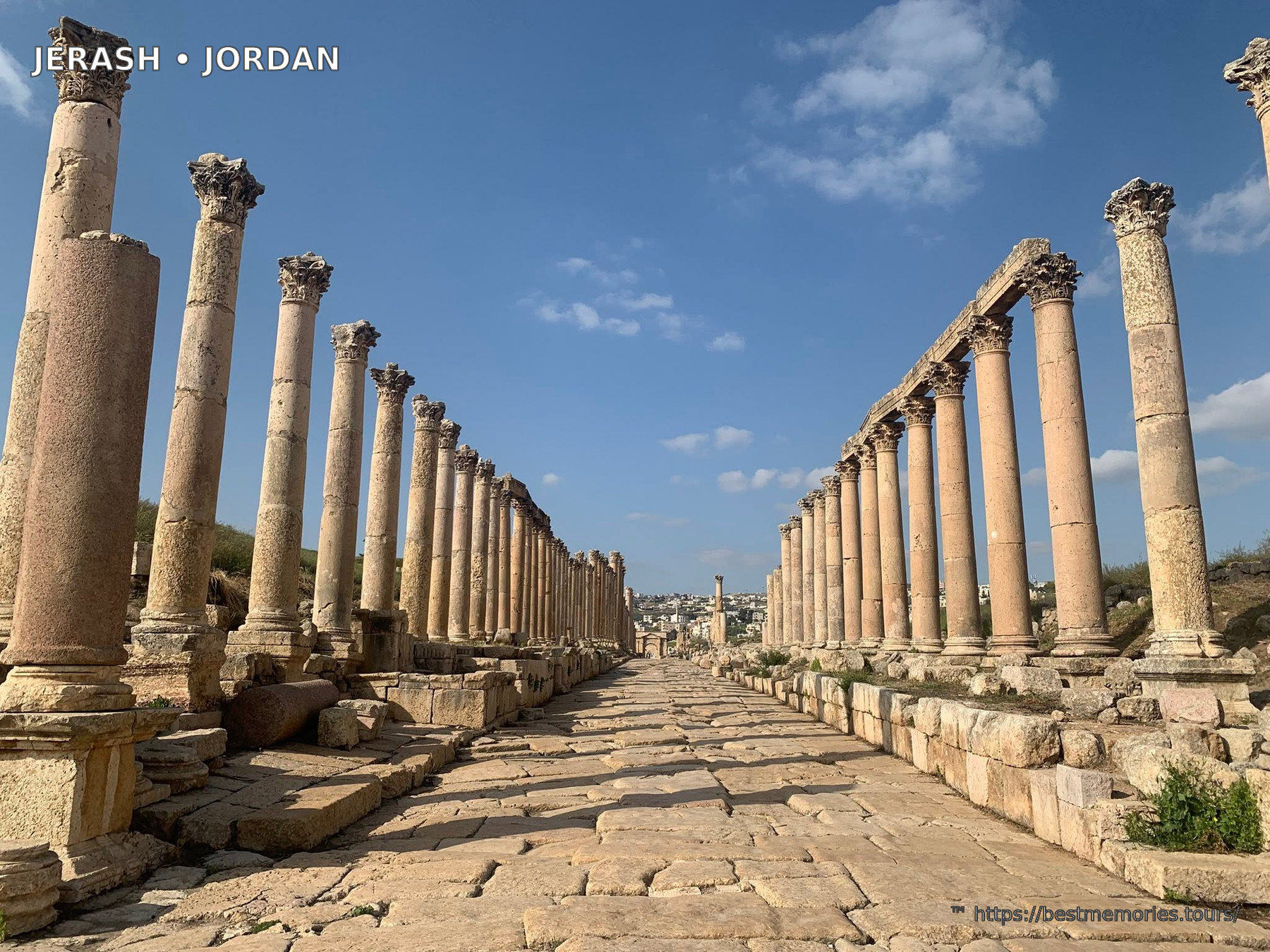
The Cardo Maximus is Jerash’s great colonnaded street, running for roughly 800 meters through the ancient center. Original stone slabs survive underfoot, and wheel wear can be seen in places. Columns once supported covered walkways fronting shops and public buildings. Side streets crossed the Cardo at monumental intersections, organizing movement through a dense city. Walk slowly: pavement, drains, thresholds and column bases reveal daily systems that broad panoramic photographs often miss.
A drainage network beneath the paving carried seasonal water away from the street. The columns are not all identical because construction, repair and changing styles occurred over time. The South Tetrapylon and North Tetrapylon marked important crossroads with monumental architectural forms. Looking down lateral streets helps reconstruct Gerasa beyond the ceremonial center, toward residential neighborhoods, baths and structures that remain less immediately visible.
The Nymphaeum, agora and public life
The Nymphaeum was a lavish public fountain built in the second century AD. Water, sculpture, colored stone and a high semicircular facade would have created a cool sensory landmark beside the Cardo. The structure illustrates how Roman cities displayed water as both public service and civic theater. Its basins and decorative niches are incomplete, but enough survives to understand the original composition. Nearby building remains have been interpreted as shops, markets and gathering places.
Gerasa required aqueducts, reservoirs and distribution systems to support residents, bath complexes and fountains. Public water made urban life possible while proclaiming prosperity. Commercial spaces along the main streets brought together rural produce, manufactured goods and regional trade. Rather than imagining everyone attending temples and spectacles all day, picture porters, craftspeople, sellers, officials, families and travelers sharing the same paved network.
Temple of Artemis
The Temple of Artemis occupied one of the city’s grandest sanctuaries. Artemis was Gerasa’s patron goddess, and the approach involved a monumental staircase and processional spaces. Eleven tall Corinthian columns remain standing, giving the precinct exceptional vertical presence. Their engineering has endured earthquakes and centuries of weathering. Guides sometimes demonstrate slight movement in a column using a spoon or key, but visitors should never wedge objects into joints or interfere with the ancient fabric.
The sanctuary was designed to impress from multiple approaches. Propylaea opened from the Cardo, stairs climbed toward the sacred terrace, and the temple stood within a large enclosure. Later communities reused portions of the area, a reminder that monuments acquired new functions as religious and political life changed. From the upper precinct, views across Jerash help connect the Cardo, theaters and surrounding hills into one urban plan.
North Theatre and northern monuments
The North Theatre began as a smaller performance and council space before expansion. Inscribed seat divisions provide evidence of civic organization and particular social groups. Its more intimate proportions contrast with the South Theatre and offer another way to think about meetings, music and public identity. Nearby, the North Tetrapylon, North Gate and stretches of colonnaded street show how the city extended well beyond the Oval Plaza.
Visitors on a rushed half-day sometimes turn back too early. Continuing north rewards anyone interested in quieter architecture and the full scale of Gerasa. The terrain remains exposed, and the return adds distance, so balance curiosity with weather and mobility. A guide can adapt the route, prioritizing the best-preserved monuments without presenting every block as equally significant.
Byzantine churches and mosaics
Jerash contains numerous churches, reflecting a flourishing Christian city in late antiquity. The Cathedral complex, Church of Saint Theodore and a group associated with Saints Cosmas and Damian, Saint John and Saint George reveal changing use of urban space. Some churches incorporated stone from earlier buildings, as was common in cities whose needs and institutions evolved. Mosaic pavements feature geometric, vegetal and figurative designs as well as dedicatory inscriptions.
Mosaics are fragile. Keep to marked paths and do not step onto uncovered floors unless an official route explicitly permits it. Seasonal protection or conservation may limit what can be seen. The churches are essential to Jerash’s story because they challenge the idea that its importance ended with the high Roman Empire. Byzantine and early Islamic layers show adaptation, continuity and changing communities across the same city.
Practical planning for a Jerash visit
Most travelers need about three to four hours for a satisfying first visit, while archaeology enthusiasts can spend longer. The route includes uneven paving, steps and broad areas with little shade. Supportive shoes, water, a hat and sun protection are useful in warmer months. Winter and spring can be cool or wet, and stone becomes slippery. Verify current opening arrangements through official sources and avoid relying on old prices or timetables.
An early start can offer cooler conditions and a quieter Oval Plaza. There is no single perfect photography hour: the site faces several directions, and cloud, season and dust alter the light. Toilets, refreshments and visitor facilities are concentrated near the entrance area, so plan before walking deep into the ruins. Keep tickets accessible if required and obey any temporary barriers around active conservation.
Jerash suits families who are comfortable walking, history-focused travelers and anyone seeking context before or after Petra. Mobility varies across the site; some principal areas may be approachable, but ancient paving and elevation create challenges. Ask the visitor center or tour operator for current, specific advice instead of assuming the entire archaeological park is step-free.
Jerash from Amman and northern Jordan
Jerash is an easy road trip from Amman, commonly taking around an hour depending on traffic and pickup point. It pairs naturally with Ajloun Castle and the forested northern highlands. Another longer northern itinerary may continue toward Umm Qais, ancient Gadara, for basalt ruins and views over the Yarmouk region. Trying to combine all three with a detailed Amman visit can feel rushed, so choose priorities and realistic driving time.
A licensed guide helps decode the site’s chronology and prevents the largest monuments from blending together. Good interpretation explains why the Oval Plaza has its shape, how a colonnaded street worked, and why churches stand among temples. Browse the related Jerash and Amman tours on this page for an efficient introduction to Jordan’s capital and Roman north, or select a northern route if landscape and medieval history are equal priorities.
Why Jerash matters
Jerash provides an unusually legible record of urban life east of the Mediterranean. Imperial architecture is part of the experience, but local religion, agricultural wealth, civic competition and later Christian and Islamic communities are equally important. The ruins survived through reuse, burial, excavation and conservation—not because time stopped. That layered history makes the city more interesting than its nickname suggests.
Allow moments to stand back from the checklist. Listen in a theater, trace a side street from the Cardo, compare column styles and look from Artemis’s terrace toward the modern city. Ancient Gerasa is not an inscribed UNESCO site, but it needs no exaggerated status to justify a visit. Its scale, setting and continuity make Jerash one of the strongest archaeological experiences in Jordan.
Photo Gallery
How to Visit
Jerash is just 50 minutes north of Amman. The site is large and its stories need telling — a licensed private guide brings the stones to life. Our Jerash & Amman City Tour covers the ruins in the cool morning hours and pairs them with the capital's Citadel, Roman Theatre and souks in one full day, entrance fees and pickup included.