Petra: The Rose Red City of Jordan - Complete Visitor Guide
The Rose-Red City — One of the New Seven Wonders
Petra Jordan: an essential introduction
Petra is an ancient Nabataean city hidden among the sandstone mountains of southern Jordan. Its rock-cut facades are famous, but the archaeological landscape is much larger than a single monument. Tombs, temples, processional routes, houses, quarries, water channels and high places spread across valleys and ridges. Visiting Petra means walking through a city shaped as much by trade, engineering and ritual as by dramatic architecture. It is a place to explore slowly, with time to notice the details carved into the stone.
The site became a UNESCO World Heritage Site in 1985 and was selected as one of the New Seven Wonders of the World in 2007. Those distinctions reflect its exceptional cultural importance, yet Petra is not a frozen stage set. Local Bedouin communities have deep connections with the landscape, archaeologists continue to study it, and every route reveals traces of different periods. The Nabataean city is central to the story, while Roman, Byzantine and later remains show how life continued as political and commercial networks changed.
Who built Petra?
The Nabataeans were an Arab people whose kingdom prospered by connecting Arabia, the Mediterranean and the wider Near East. Petra developed as their capital from around the fourth century BC, occupying a defensible basin near valuable caravan routes. Traders moved frankincense, myrrh, spices, textiles and other goods across long desert distances. The Nabataeans gained wealth and influence by understanding those routes, protecting water sources and serving the commercial world that passed through their territory.
Their architecture combined local traditions with ideas drawn from Egypt, Greece and the Hellenistic and Roman worlds. At Petra, that exchange appears in carved capitals, stepped motifs, monumental doorways and elaborate tomb fronts. The result is not simply borrowed classical design: it is a distinctive Nabataean visual language cut into native sandstone. In AD 106, Rome annexed the Nabataean kingdom. Petra remained important for centuries, although trade patterns shifted and earthquakes contributed to a gradual decline. Byzantine churches demonstrate that the city retained a significant Christian community long after annexation.
Petra was never truly “lost” to the people of the region. Western awareness diminished, and the Swiss traveler Johann Ludwig Burckhardt reached the site in 1812 while traveling in disguise. His account helped return Petra to wider European attention. Nineteenth-century artists, scholars and travelers then publicized its monuments, sometimes romanticizing the city while overlooking local knowledge. Modern archaeology has created a more complete picture of Petra as a living urban center rather than a mysterious collection of tombs.
Walking through the Siq
Most visits begin at the visitor center in Wadi Musa and follow the broad path toward the Bab as-Siq, or gateway to the Siq. Before the canyon entrance, the Obelisk Tomb and the Bab as-Siq Triclinium introduce two themes that recur throughout Petra: commemoration and communal dining. The carved monuments also reveal how the Nabataeans used entire cliff faces, planning architecture in relation to the natural form and color of the rock.
The Siq is a narrow geological gorge about 1.2 kilometers long. It was created by natural tectonic forces and later refined as Petra’s ceremonial entrance. In places its walls rise roughly 80 meters, turning the walk into a sequence of shade, reflected color and tightly framed sky. The route slopes gently, but the stone surface can be uneven. Walking rather than rushing allows you to see niches, worn reliefs and traces of paving that explain how the entrance functioned in antiquity.
Water channels run along both sides of the Siq. Ceramic pipes, settling basins and small dams formed part of an advanced system that carried drinking water while managing dangerous flash floods. A weathered relief once showed camels and their handlers approaching the city; the surviving feet are easy to miss without a guide. Sacred niches appear at intervals, suggesting that the journey was also ritualized. These modest features often tell more about Nabataean skill and belief than the largest facade.
The Treasury, or Al-Khazneh
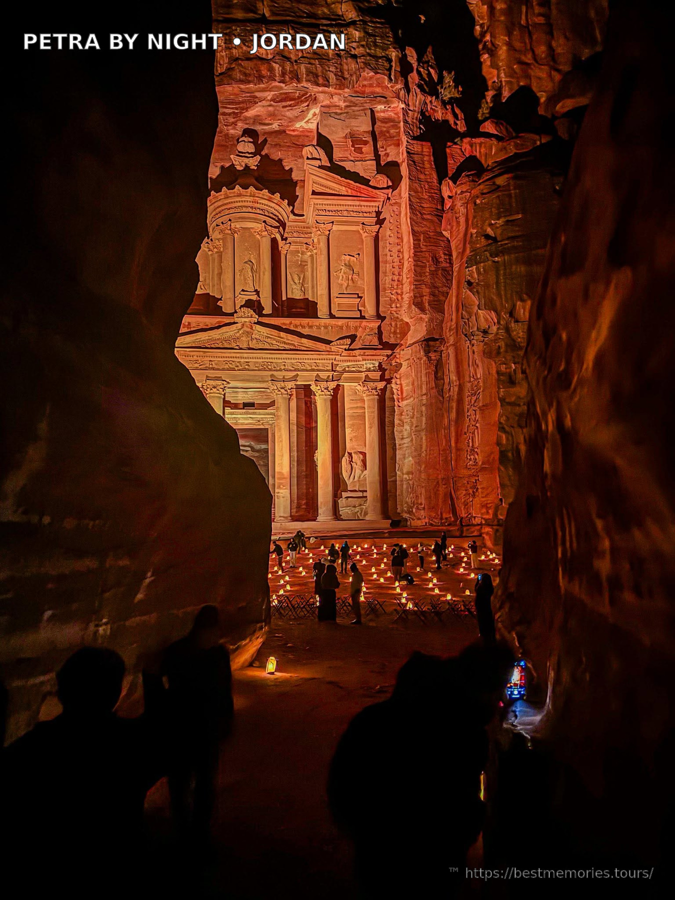
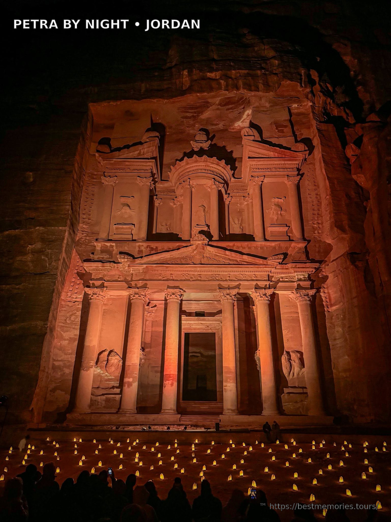
At the final turn, the canyon opens onto Al-Khazneh, the Treasury. The sudden reveal is carefully framed and remains one of travel’s great visual experiences. Its facade is almost 40 meters high and was carved from the top downward, probably in the first century BC or first century AD. Despite the modern name, it was almost certainly a royal or elite tomb rather than a storehouse. The interior is comparatively plain, shifting attention toward the extraordinary exterior composition.
Look beyond the first impression. Columns, pediments, figures and the central tholos show a sophisticated blend of classical influence and Nabataean meaning. Bullet marks on the urn are associated with stories that treasure was hidden inside, but the urn is solid stone. Morning conditions often illuminate the facade, though the exact effect changes with season and weather. Visitors should remain in designated public areas and follow site guidance; elevated unofficial viewpoints can involve unsafe climbs and access concerns.
From the Street of Facades to the city center
The main route continues into the Outer Siq and past the Street of Facades, where rows of tombs demonstrate the variety of Nabataean funerary design. Nearby, the rock-cut Theatre occupies the slope. It was created in the Nabataean period and altered after Roman annexation. Thousands of spectators could gather here, and sections of older tombs were cut away during construction. That overlap is a vivid example of how Petra’s urban landscape evolved rather than following one fixed master plan.
Across the valley, the Royal Tombs dominate Jabal al-Khubtha. The Urn, Silk, Corinthian and Palace Tombs differ in scale, decoration and sandstone patterning. Late-afternoon light can bring out red, gold and purple bands in the cliffs. The climb to their terraces adds perspective over the central valley. A longer trail continues toward a high view across from the Treasury, but it requires time, suitable footwear and confidence on steps. Ask locally about route conditions before setting out.
The Colonnaded Street leads through Petra’s civic heart. Here visitors encounter the Nymphaeum, market areas, the remains of a monumental gate and the Qasr al-Bint temple. The Great Temple nearby was a vast ceremonial complex whose exact use remains debated. Excavations have revealed stairways, columns and an unusual small theater-like space. These structures correct the common idea that Petra consists only of tombs: this was an organized capital with public space, worship, administration and everyday commerce.
Petra Church sits on a rise north of the street and preserves impressive mosaic floors with animals, people and personifications of the seasons. A cache of carbonized papyrus documents found here transformed knowledge of Byzantine Petra. They record property, marriage and family affairs, bringing individual residents into focus. Nearby churches and domestic remains show that the city adapted after the Nabataean and Roman eras. Check which excavated areas are open during your visit and respect barriers protecting fragile surfaces.
Climbing to the Monastery
Ad-Deir, the Monastery, is one of Petra’s largest monuments. Reaching it involves a sustained ascent traditionally described as about 800 rock-cut steps from the Basin area. The trail passes ravines, open views and small refreshment points before the enormous facade appears. At roughly 47 meters wide and 48 meters high, it feels broader and more monumental than the Treasury. Its modern name comes from crosses added inside during a later period; it may originally have had a funerary or ceremonial purpose.
Allow enough energy for the return journey. The climb is manageable for many active travelers when taken slowly, but heat and accumulated walking make it harder than the number of steps suggests. Carry water, protect yourself from the sun and pause without blocking the path. Beyond the main viewing area, signed viewpoints look toward the mountains and Wadi Araba. Do not approach exposed cliff edges for photographs. Travelers with limited time can prioritize the main trail rather than treating the Monastery as compulsory.
High Place of Sacrifice and alternative trails
The High Place of Sacrifice trail climbs above the main valley to a ceremonial platform with rock-cut altars and wide mountain views. A rewarding route can descend through Wadi Farasa past the Garden Triclinium, Roman Soldier Tomb and other quieter monuments. This is a more demanding experience than the central path and navigation is not always obvious. A licensed local guide adds both interpretation and practical confidence, particularly when combining less visited trails or adjusting plans around heat.
Other hikes connect Little Petra, Jabal al-Khubtha and overlooks around the basin. Trail availability and official access arrangements can change, so current information should come from the visitor center or authorized guides. Petra’s scale tempts visitors to pack in too much. A focused route with time to observe is usually more satisfying than racing between distant landmarks. Internal Jordan itineraries often pair Petra with nearby Little Petra, then continue south to Wadi Rum or Aqaba.
Nabataean water engineering
Petra receives seasonal rain but lies in an arid environment vulnerable to both drought and flash floods. Nabataean engineers responded with channels, pipes, dams, cisterns and reservoirs distributed through the city and surrounding catchment. They diverted violent runoff, reduced erosion and stored water for residents, gardens, animals and visiting caravans. The system depended on maintenance and careful control. Its surviving traces demonstrate that Petra’s success rested on infrastructure as much as trade or artistic ambition.
Watch for plastered channels beside paths, cut-water conduits and the remains of dams near the Siq. These details help explain how a major population could thrive here. They also make modern safety rules easier to understand: flash floods remain a genuine natural hazard. In unstable weather, authorities may restrict or close areas. Travelers should follow official instructions promptly, avoid entering closed wadis and never assume that clear skies directly overhead mean every upstream catchment is dry.
How much time do you need in Petra?
One full day allows a first-time visitor to walk through the Siq, see the Treasury and central monuments, and choose either the Monastery or another substantial climb. It is a long day with considerable distance. Two days provide a more balanced experience: the first can cover the main trail and Monastery, while the second explores the Royal Tombs, churches or High Place of Sacrifice. A third day suits keen hikers, photographers and travelers who enjoy archaeology in depth.
Petra by Night is a separate evening experience offered on selected nights when operating. Candles line the Siq and the program gathers in front of the Treasury. It creates a different atmosphere but does not replace a daylight visit, when carvings, trails and the city center can actually be studied. Schedules and access can change, so verify details through official local sources rather than building an itinerary around old online information.
Best time to visit and what to bring
Spring and autumn usually provide comfortable hiking conditions, but they are also popular seasons. Winter can bring cold mornings, rain and occasional snow at elevation. Summer days can be very hot, especially on exposed climbs. Starting early helps with temperature and leaves flexibility for a longer route. Light varies throughout the day and season; photographers should plan for changing contrast rather than expect one guaranteed moment at every monument.
Wear supportive footwear with reliable grip. Petra involves stone paving, sand, irregular steps and significant elevation even on standard itineraries. Bring water, sun protection and layers appropriate to the forecast. A small daypack is more practical than bulky luggage. Modest clothing is respectful and can protect against sun. Keep snacks secure, take rubbish out, and avoid touching carvings. Travelers with mobility needs should seek current, individualized access advice because terrain and available services vary.
Responsible travel in Petra
Choose licensed guides and authorized services, agree clearly on any optional service before accepting it, and follow animal-welfare guidance. Walking is the best way for many visitors to understand the site, but individual needs differ. Do not climb monuments, carve names or leave locks and other objects. Archaeological stone is vulnerable, and seemingly minor contact accumulates across millions of visits. Ask permission before photographing local people and be considerate around homes, stalls and working areas.
Wadi Musa provides hotels, restaurants and practical services beside the archaeological park. Staying locally supports a longer, less rushed visit and makes an early entrance easier. Little Petra, also called Siq al-Barid, lies north of the main site and contains carved spaces associated with Nabataean activity. It works well as a quieter complement, not a substitute. Together, these landscapes make Petra much more than a checklist stop: they reveal a resourceful society that transformed desert terrain into a cosmopolitan capital.
Planning Petra within a Jordan itinerary
By road, Petra is commonly reached from Amman via the faster Desert Highway or the slower, scenic King’s Highway through places such as Madaba, Wadi Mujib viewpoints, Karak and Dana. Driving times depend on route and stops, so a private itinerary should leave realistic margins. Southbound journeys often continue to Wadi Rum, while Aqaba offers Red Sea relaxation after several walking-intensive days. Browse the related tours on this page to compare routes that connect these destinations without backtracking.
A knowledgeable guide can translate weathered details into an understandable city: how water entered the Siq, why tomb styles differ, where religious processions moved and how archaeology changes old assumptions. Independent exploration remains rewarding, but guided context is especially useful on a first visit. Petra’s enduring power comes from the combination of landscape and human ingenuity. The famous rose red city reveal is only the beginning; the deeper memory is of an entire mountain basin shaped by generations.
Photo Gallery
How to Visit
Petra is a 3-hour drive south of Amman, and by far the best way to experience it is a private tour with a licensed guide — the site covers over 60 km² and its stories are invisible without local knowledge. Our Petra Full Day Tour includes hotel pickup anywhere in Jordan, entrance fees, a licensed guide and lunch, and multi-day options combine Petra with Wadi Rum and the Dead Sea.